

A Hiker's Paradise.
Hiking in Zion National Park is delightful. Whether you prefer flat pavement, rocky trails, or secret off-trail nooks and crannies, gorgeous opportunities await here. Famous Zion hikes like Angels Landing and the Narrows dominate the magazine pages and internet galleries, but there are PLENTY more choice routes and destinations to explore by foot here. You could easily spend a lifetime doing so.
If you have never visited Zion before, by all means hike the big names first: Angels Landing, the Zion Narrows, Emerald Pools, and Observation Point are world-renown Zion hikes for good reason. Once Zion hooks you, come back to explore equally beautiful places that are a little (or a lot) more difficult to get to. You'll be glad you did.
We've grouped all the Zion hikes into six geographic areas of the Park (see below) to help you organize your Zion hiking plans. Since trailheads here can be far from each other, it often makes sense to hike in the same area on any given day, then move to another area the following day. Each area has distinctive geology, flora, and fauna, so visiting different Zion hiking areas will reveal more diversity during your visit.
The below trails are all official Zion hikes, signed and maintained by the National Park Service. For additional Zion hiking opportunities, see our Off-Trail Hikes page.
Zion Hiking Trails
Main Canyon
Click on a trail name to read a full description
| Hike Name | Round-Trip Length (mi/km) | Quality | Elevation Gain(ft/m) | Time | Permit |
|---|---|---|---|---|---|
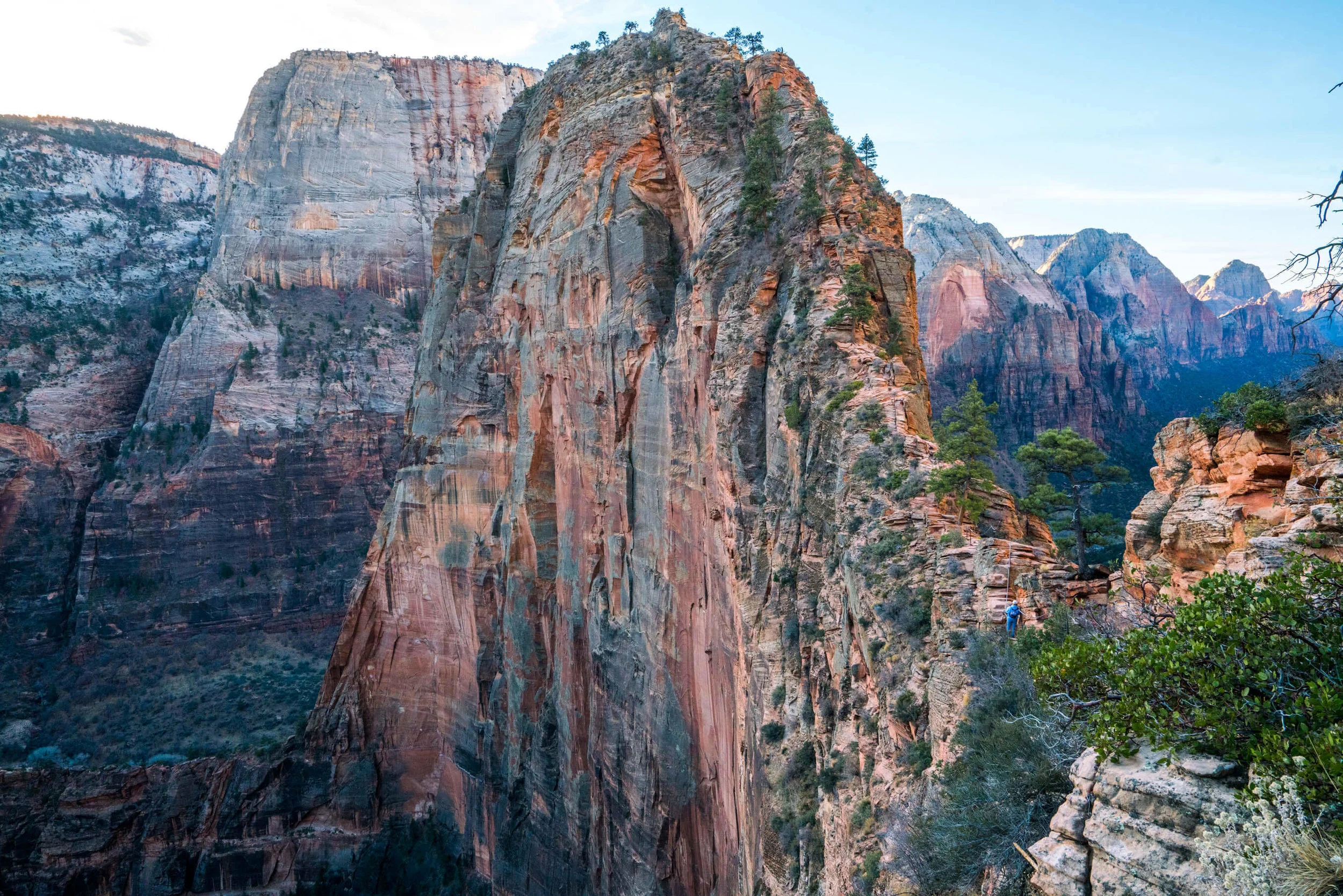
| ANGELS LANDING | 5.8mi/7.6km | ★★★★★ | 1500ft (450m) | 3-5 hrs | No |
| EMERALD POOLS | 2.1 to 3mi/3.4 to 4.8km | ★★★★ | 400ft (120m) to Upper | 1-3 hrs | No |
| HIDDEN CANYON | 2.2+mi/1.8km | ★★★★ | 970ft (300m) | 3-4 hrs | No |
| OBSERVATION POINT | 6.5mi/10.4km | ★★★★★ | 2270ft (700m) | 4-7 hrs | No |
| RIVERSIDE WALK | 2mi/3km | ★★★★ | 60ft (17m) | ~1 hr | No |
| SAND BENCH | ~4mi/6km | ★★★ | 500ft (152m) | 1-2 hrs | No |
| WATCHMAN | 3.5mi/5.3km | ★★★★ | 370ft (112m) | ~2 hrs | No |
| WEEPING ROCK | 0.5mi/0.8km | ★★★★ | 100ft (30m) | 0.5 hrs | No |
| WEST RIM FROM THE BOTTOM | Up to 9mi/15km | ★★★★ | 2500ft (760m) | 4-8 hrs | No |


East Side Hikes
Click on a trail name to read a full description.
| Hike Name | Round-Trip Length (mi/km) | Quality | Elevation Gain(ft/m) | Time | Permit |
|---|---|---|---|---|---|
| CABLE MOUNTAIN | 15.5mi/25km (From Weeping Rock) 17.5mi/28km (from E Entrance) 7.5mi/12km (from Zion Ponderosa) |
★★★★ | 2100ft/640m (From Weeping Rock) 1000ft/300m minus 2000ft/600m descent (from E Entrance) 300ft/90m (from Zion Ponderosa) |
5 hrs to 2-3 backpack | Only if overnighting |
| CANYON OVERLOOK | 1mi/1.6km | ★★★★★ | 63ft (50m) | 45 minutes | No |
| DEERTRAP MOUNTAIN | 17.5mi/28km (From Weeping Rock) 19.5mi/30km (from E Entrance) 9.5mi/15km (from Zion Ponderosa) |
★★★★ | 2100ft/640m (From Weeping Rock) 1000ft/300m minus 2000ft/600m descent (from E Entrance) 300ft/90m (from Zion Ponderosa) |
8 hrs to 2-3 backpack | Only if overnighting |
| EAST MESA | 3.4mi/5.4km | ★★★★ | 280ft (85m) | 3-4 hrs | No |
| EAST RIM | 10.6mi/17.1km from Weeping Rock to E Rim Trailhead | ★★★★ | 1365ft (415m) | 5-7 hrs | Only if overnighting |


KOLOB TERRACE HIKES
Click on a trail name to read its full description
| Hike Name | Round-Trip Length (mi/km) | Quality | Elevation Gain(ft/m) | Time | Permit |
|---|---|---|---|---|---|
| NORTHGATE PEAKS | 4.5mi/7.2km | ★★★★ | 250ft (76m) | 2-3 hrs | No |
| RIGHT FORK BOTTOM-UP | 10.6mi/17km | ★★★★ | 1000ft (300m) | 8-12 hrs or overnight | Only if overnighting |
| SUBWAY - BOTTOM-UP | 4-7mi/10.6km | ★★★★★ | 1000ft (300m) | 6-10 hrs | YES |
| WEST RIM | 12.9mi/20.7km or 14.4mi/23.1km one-way depending on variation |
★★★★★ | 500ft (150m), 3650ft (1100m) elevation loss |
6-12 hrs, or overnight | Only if overnighting |

Kolob Canyons
Click on a trail name to read its full description
| Hike Name | Round-Trip Length (mi/km) | Quality | Elevation Gain(ft/m) | Time | Permit |
|---|---|---|---|---|---|
| HOP VALLEY | 7.5mi/10.5km from La Verkin Creek to Hop Valley Trailhead or 15mi (24.1km) roundtrip from Hop Valley Trailhead to Kolob Arch |
★★★★ | 1000ft (300m) | 5-10 hrs | Only if Overnighting |
| KOLOB ARCH | 8.8mi/14km roundtrip to first campsites. An extra 4.6 round-trip to Kolob Arch viewpoint | ★★★★ | Descends 1070 feet (330 m) to La Verkin Creek, then climbs 320 feet (100 m) to Kolob Arch viewpoint. So keep in mind, you hike UPHILL from La Verkin Creek at the end of the day. | 6-10 hrs or overnight | Only if overnighting |
| TAYLOR CREEK | 6.4mi/10.2km | ★★★★★ | 1050ft (320m) | 2-4 hrs | No |


Southwest Desert
Click on a trail name to read its full description
| Hike Name | Round-Trip Length (mi/km) | Quality | Elevation Gain(ft/m) | Time | Permit |
|---|---|---|---|---|---|
| CHINLE TRAIL | 6.8 miles (11 km), roundtrip to Huber Wash; or 8.1 miles (13 km) one-way to the Coalpits Wash Trail Junction; about 15 miles from Chinle Trailhead to Coalpits Trailhead | ★★★ | 390 feet (119 m) | 3-5 hours roundtrip to Huber Wash, or 4-6 hours one way to the Coalpits Wash Junction, 2 days for Chinle-Coalpits backpack | Only if Overnighting |
| COALPITS WASH | 2.8 miles (4.6 km), roundtrip to the Chinle Trail Junction, 16 miles (25.7 km) roundtrip to the head of Coalpits Wash and back | ★★★ | 500-1000 feet (160-320 m); the trail is steadily uphill | 1.5 to 10 hours, depending on how far you want to explore | Only if overnighting |
| GRAFTON | No official trails, just old dirt roads | ★★★ | Zero | 30 minutes to an hour of exploring | No |


South of Zion
Click on a trail name to read its full description
| Hike Name | Round-Trip Length (mi/km) | Quality | Elevation Gain(ft/m) | Time | Permit |
|---|---|---|---|---|---|
| EAGLE CRAGS | 5 miles (8.5 km) roundtrip | ★★★★ | 900 feet (270 m) | 3-5 hours | No. This is BLM land, so backpacking and/or dogs are allowed. |
| SQUIRREL CANYON | 6 miles (9.7 km) out-and-back, or 11 miles (17.7 km) as a loop | ★★★★ | 2900 feet (870 m) | 4 - 5 hours (out-and-back) or 6 - 10 hours (loop) | No. Dogs and overnight backpacking allowed without a permit. |
| WATER CANYON | 10 rugged miles (17 km) | ★★★ | 1200 feet (360 m) | 3-7 hrs | No. Dogs and backpacking allowed. |

